This website uses cookies to improve your experience. We'll assume you're ok with this, but you can opt-out if you wish. Read More
dirty 30K
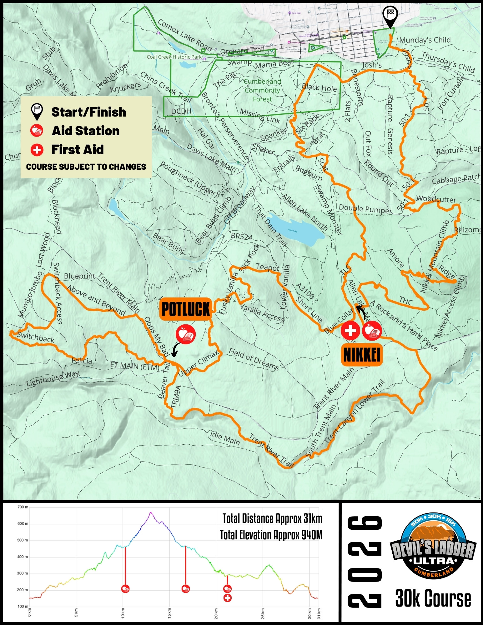
30k (31km / 940M Elevation)
Aid Stations / Cut-offs
1. POTLUCK (Cut-off 3.00 hours)
2. POTLUCK (second time) (Cut-off 4.00 hours)
3. NIKKEI (Cut-off 5.50 hours)
FINISH – 31KM FINISH (Cut-off 7.00 hours)
*Depending on your watch/GPS, distances may vary. Many athletes find the 30k course to read 33-34km.
Course Description
The 30k is a challenging course that features some of the best running trails in the Cumberland Trail Network and includes:
- A combination of buttery smooth and flowy singletrack with a sprinkle of technical sections to keep you on your toes
- Calf aching climbs
- Quad crushing descents
- A few sections of logging roads to visit one of our aid stations to fuel your body for the next epic section of singletrack
- A sightseeing tour including breathtaking vistas, lakes, rivers, waterfalls, mountains and mature Coastal Douglas Fir
You will leave from Village Park and be treated to a nice easy start along the gravel Colliery Line trail. From here, the trail starts ascending on a forested double track to get the blood pumping! Take a singletrack cruise on trails like Spanker, Lost Toque and Middle Crafty Butcher until you reach Double Track Connector (Branch 69).
You are roughly 5 kilometres in when you reach the tranquil singletrack of Amore and Blue Collar. We are guessing your legs are warmed up by now? Good, you have more climbing to do! The course continues on Teapot and Upper Climax which both offer beautiful views of the mainland mountain ranges on a clear day. Your first aid stations will be located on Trent River Main at approximately km 10.
The course completes an approximate 6-kilometre loop utilizing trails like Potluck and Switchback which offer excellent wooden bridges and elevated boardwalks. At km 16 you are back at the first aid station so you can grab some extra snacks and beverages if you feel like you didn’t get your fill the first time around.
The route continues on Beaver Tale which connects to the beautiful singletrack Trent Canyon Trail. The Trent Canyon Trail meanders above at first, and later parallel to the Trent River for roughly 5 kilometres of up-and-down rolling singletrack. Depending on water levels, you might even get to see a couple of waterfalls on the way. You will reconnect with the Trent River Main again at km 22 and cruise some logging roads up to A Rock and a Hard Place.
You will be treated to some more rolling singletrack through this section. We suggest using this time to mentally prepare for the upcoming switchback ascent up Nikkei Mountain at km 25. The top of Nikkei offers beautiful views of the Beaufort mountain range and valley below. Time to descend (well mostly) to the finish! Descend on the downhill stretch of the flowy Banzai Express Lane and the steeper Woodcutter trails. We’ve included Upper 50:1, Middle 50:1 and Lower 50:1 trails to bring you down to the final stretch. One last kick on a nice access road, and through the grass field at Village Park will bring you to the finish line!
COURSE MAPS
This year’s course is expected to be the same or very similar to last year’s. We will post an updated map closer to the race date.
The course will be well marked, but it’s advisable to acquaint yourself with the course before the race. There is a map below, in addition to a GPX file which you can download and import to your watch or other device.
If there are last-minute course changes, the GPX file may not be updated.